
CAWa - a regional research network for "Water in Central Asia"

- Subject: Agriculture and water management
- Study site: Central Asian (Kyrgyzstan, Uzbekistan, Tajikistan, Turkmenistan and Kazakhstan)
- Funding: Framework of the Berlin Process of the Federal Foreign Office
- Contact: Christopher Conrad
Water is a scarce and precious but unevenly distributed source in between the different countries in central Asia. The aim of the project "Water in Central Asia" (www.cawa-project.net) is to build a scientific and technical data basis for a sustainable water management on a cross-national level. Therefore, water availability and water use will be analysed under different climatic scenarios. The project is funded by the Department for Foreign Affairs in the context of the process of Berlin until 2017.
The project is coordinated at the German Research Centre for Geosciences (GFZ). Further partners are among others the German Aerospace Center (DLR), the Scientific-Information Center of the Interstate Coordination Water Commission of the Central Asia (SIC ICWC), the Regional Environmental Centre for Central Asia (CAREC), the Khorezm Rural Advisory Support Service (KRASS) and the Central-Asian Institute for Applied Geosciences (CAIAG).
Since 2009 the department for remote sensing of the University of Würzburg is included in the CAWa project and works on the workpackage "Remote Sensing Products and Integration of Data". In particular, we provide parameters for hydrological modelling and develop a monitoring system for irrigated areas. The spatial focus is on the upper water catchments of Aral Sea, and the downstream irrigated areas of the Amu Draya Delta and Ferghana valley (Uzbekistan).
Yearly land cover and land use maps for the irrigated areas are produced in order to estimate the agricultural area under production as well as the most important crops for the years 2001 to 2009. These classifications are based on high resolution data like Landsat (30m resolution) and the very new sensor RapidEye (5m) as well as MODIS Data (250m) for the classification of large areas.
The web-based application “Water Use Efficiency Monitor for Central Asia” (WUEMoCA) is the focus of CAWa work package 3 (“Online Tool for Monitoring of Land Use and Water Efficiency”) during the 3rd phase of the CAWa project in 2015-2017.
This online tool is intended for the regional assessments of water use efficiency in all extensive downstream irrigation systems of the transboundary Aral Sea Basin. The first aim is to provide information about crop yields of the major crops, i.e. cotton, rice, and wheat, based on free-of-charge accessible remote sensing (MODIS 250 m) and meteorological data aggregated at different scales ranging from districts (rayons) to irrigation planning zones, and provinces (oblasts). This monitoring application can be used as an early warning tool for the localization of agricultural droughts and the prognosis of harvest shortfalls.
Complementary to the monitoring application, the WUEMoCA tool will encourage user interaction. Thus, users will be allowed to add hydrological data like irrigation water amounts. This data can be used to calculate the water use efficiency, i.e. how much water was used for crop production t/ha. The user will be enabled to define a specific area of interest, for which efficiency indicators can be calculated.
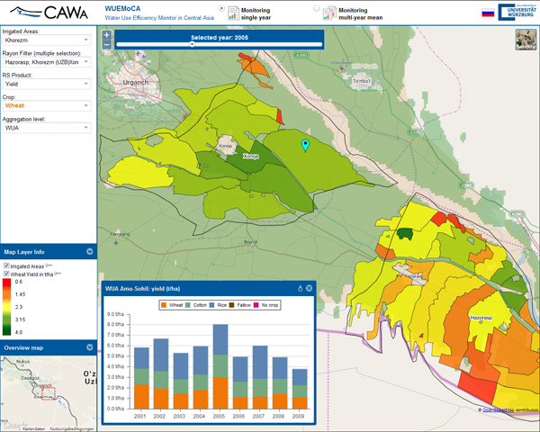
Figure: User Interface of the first test version of WUEMoCA. The user can select regions, map types, periods, and aggregation levels and explore the results in spatial (maps) and temporal (time series) distribution. Here the map shows the WUAs (“Water User Associations”) of two districts of the irrigation zone “Khorezm” in Uzbekistan with the yield (t/ha) of wheat in 2005. The diagram is showing the share of all three crops wheat, cotton and rice of one selected WUA (“Amu-Sohil”) from 2001 to 2009.
Contact: Dipl.-Geogr. Lucia Morper-Busch

