
EIFER
In the course of global change and increasing land consumption, concepts for an efficient and sustainable land management, both in Germany and in Europe are in increasing demand. High-resolution land use classifications from satellite data can provide this comprehensive information. The calculation of alternating crop rotations and the spatial variation of cultivated area are examples of an agricultural monitoring.
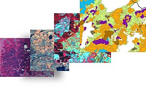
The aim of this study is to develop a method for a classification of agricultural land with remote sensing data. Based on this, straw potentials and the spread of cereal fields are detected. The requirements include the transferability to other areas as well as time and cost savings compared to alternative methods such as field mapping.
The calculations are based on a multiscale and multitemporal data set. Several time steps of 15m resolution Landsat 7 ETM and 60m IRS-P6 AWiFS data are used. These are combined with field data, CORINE land cover and official cadastral land register.
The products include a comprehensive classification of crops and the information about potential areas for the retrieval of bioenergy.
Contact: Dr. Christopher Conrad

