
GlobWetland II
The overarching objective of the GlobWetland II project is to contribute to the setup of a Global Wetlands Observing System (G-WOS) as per the strategy 1.2 of the Ramsar Strategic Plan 2009-2015, Resolution X.1, recently adopted at the 10th meeting of the Conference of the Parties (COP-10) of the Ramsar Convention on Wetlands, in Changwon, South Korea. The project aims principally at developing a G-WOS pilot information system, also called the GlobWetland II information system.
The system includes maps and system software. The GW-II system software consists of 3 components:
- a remote sensing component for tasks like satellite image pre-processing, Land Use / Land Cover classification, change detection,
- GIS component e.g. for the indicator computation and
- a Web-GIS component for the permanent access to the maps and information data that have been produced during the live time of the project or provided by users and partners.
Over 200 wetland sites and surrounding areas will be selected over the coastal catchment areas of the Southern and Eastern part of the Mediterranean basin, extending from Morocco to Libya (less than 100 km from the coastline).
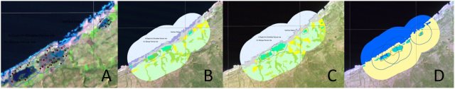
Figures A,B,C and D show the wetlands AinElzarga, Al BaydaAinElshakika und Sebkhra Gfantain Northern Libya. Intra-seasonal Landsat time series are being used to extract the inundation patterns of different RAMSAR wetland types.A showsa Landsat image of 1987, including validation points. B and C show the Landcover classes of 1987 and 2003. Seasonal water level dynamics will be used to derive basic wetland delineation maps (D).
The University of Wuerzburg focusses wetlands in Libya. For several sites landuse and landcover are classified based on multitemporal Landsat-data. The classes correspond to CORINE-landcover classes. Changes in landcover between three timesteps are computed, as well as indicators fro change. Additionally the water cycle regime is classified. For all results maps will be created.
Please find more information on the official GlobWetland-Website.
This project is funded by the European Space Agency (ESA).
Cooperations: The GW-II consortium is built around the following partners:
- Jena-Optronik GmbH (subsidiary of JENOPTIK) (Germany), Prime Contractor
- KEYOBS (Belgium), Sub Contractor
- DLR DFD (Germany), Sub Contractor
- EKBY (Greece), Sub Contractor
- TerraSphere (Netherlands), Sub Contractor
- I-MAGE CONSULT (Belgium), Sub Contractor
These 6 Contractors will be supported by experts from University of Würzburg (Germany), University of Bonn (Germany), University of IImenau (Germany) and Wetlands International (Netherlands). The University of Würzburg supports the work package of DLR concerning atmospheric corrections, geo-referencing, land use / land cover, and basic wetland delineation.
Contact: Martin Wegmann

