
Impervious Surface in Bavaria
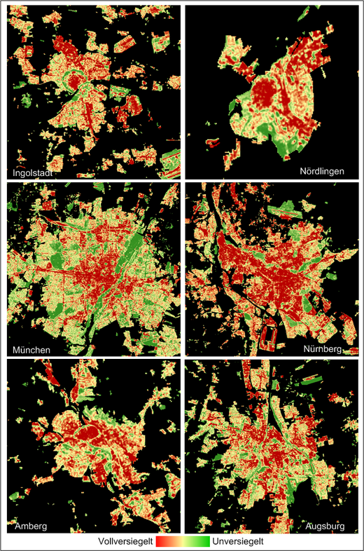
Bavaria – but also Germany - feature an increasing loss of land resources due to rapidly growing settlements and transport infrastructure. This development is strongly associated with an increase of impervious surface. Sealing of soil leads to an irreversible loss of its ecological, historical and economic functions. Moreover evapotranspiration and infiltration capability are reduced. Particularly in urban environments this development is involved with the emergence of heat islands, the reduction of humidity and increased dustiness – effects that have negative influences on the local climate.Due to these effects the identification, characterization and monitoring of impervious surface is becoming a significant issue in environmental research and policy. Nevertheless, there was no method or data base that provided the required information area-wide and updateable. Here, remote sensing technology supplies various valuable opportunities.Thus we implemented an objective, state-wide and spatially detailed survey of impervious surface by means of Support Vector machines (SVM) based on Landsat-7 imagery and ATKIS vector data. Thereby we calculated the
- total of residential, industrial and transport areas, and
- the area of impervious surface per head
for entire Bavaria and its administrative and landscape-related subdivisions.
The developed approach is based on a half-automatic method which uses techniques of digital image analysis on multispectral satellite data for the modelling of impervious surface. Therefore high resolution satellite (e.g. Ikonos) or reference data is used to generate a model for the analysis the medium resolution Landsat imagery with its significantly larger surface coverage. The large spatial coverage of the Landsat scenes is the key issue to a low-cost mapping of extensive regions.
The results of this research document that the proposed approach is qualified for an area-wide mapping of the degree of impervious surface. The assessment showed a mean absolute error of 14% and – due to a Gaussian distribution of the error around the zero value – a mean error of 0.9% for the estimation performed with a model calculated by means of reference data.
For the first time we could provide spatially detailed and precise data on the characteristics and distribution of impervious surfaces for an entire German federal state and its administrative and landscape-related subdivisions. Thus, this approach might serve as a helpful instrument in the context of future discussions on the assessment of sustainable urban development. We showed that 47.2 percent of the total residential, industrial and transport area in Bavaria is covered by impervious surface – a value that lies within the limits of earlier estimations which presumed coverage of 40 to 50 percent. The impervious surface per head comes up to 277m2.
Publications:
Esch, T., Schorcht, G., Thiel, M. (2007): Satellitengestützte Erfassung der Bodenversiegelung in Bayern. Broschüre des Bayerischen Landesamts für Umwelt (Hrsg.). ISBN (Druck-Version): 978-3-940009-24-1, ISBN (Online-Version): 978-3-940009-25-8. Bayerisches Landesamt für Umwelt, Augsburg, 2007. 16 Seiten. (PDF)
Links:
Bayerisches Landesamt für Umwelt - Flächenmanagement
Contact: Michael Thiel

