
LAST-MILE
LAST-MILE
This research project develops a numerical last mile tsunami early warning and evacuation information system (acronym: “Last-mile – Evacuation”; sponsorship code: 03G0643A-E) on the basis of detailed earth observation data and techniques as well as unsteady, hydraulic numerical modelling of small-scale flooding and inundation dynamics of the tsunami including evacuation simulations in the urban coastal hinterland for the city of Padang, West Sumatra, Indonesia. It is well-documented that Sumatra’s third largest city with almost one million inhabitants is located directly on the coast and partially sited beneath the sea level, and thus, is located in a zone of extreme risk due to severe earthquakes and potential triggered tsunamis. “Last-Mile - Evacuation“ takes the inundation dynamics into account and additionally assesses the physical-technical susceptibility and the socioeconomic vulnerability of the population with the objective to mitigate human and material losses due to possible tsunamis. This project is being developed in close cooperation with the local authorities of Padang, the Engineering Faculty of the Andalas University in Padang as well as the Indonesian research institutions. Thus, by means of modelling tsunami inundation scenarios as well as performance of evacuation processes a crucial disaster preparedness measure is made available.
The work load towards the research project objectives is divided into five work packages, based on field of expertise of each working partner, namely socio-economic vulnerability assessment (WP 1000), inundation scenarios, flow analysis (WP 2000), geodatabase, information system and vulnerability assessment (WP 3000), evacuation analysis and pedestrian traffic optimization (WP 4000) and highly-resolved 3D-model of Padang (WP5000). On the basis of satellite images and other data sources, advanced highly resolved information including topography, infrastructure, population density and settlement structures are provided.
The objectives of the WorkPackage 3000 (Remote Sensing) are:
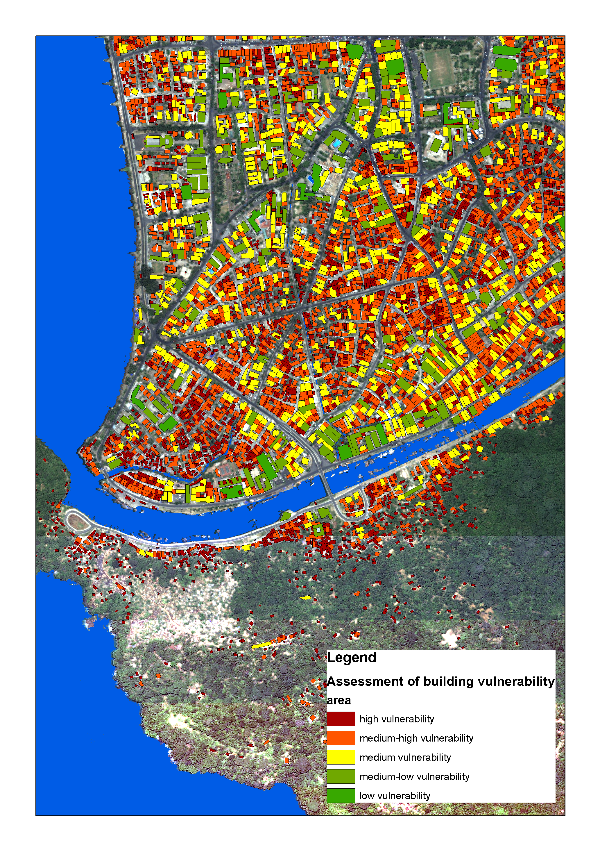
- detailed analysis of the physical vulnerability and the spatial distribution of risk for Padang (Sumatra, Indonesia) with regard to a potential tsunami impact,
- the analysis of high resolution satellite data to derive topography and urban structures to derive parameters defining vulnerability as well as the visualization of results.
- The implementation of a geo-data-base and an information system to store all results of the project for a holistic analysis and assessment.
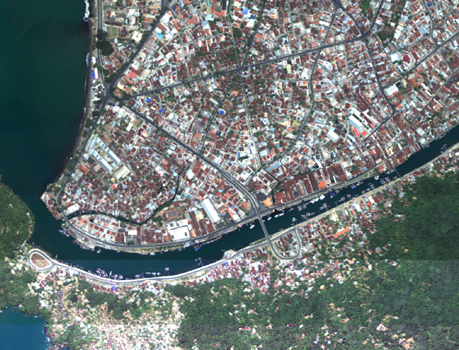
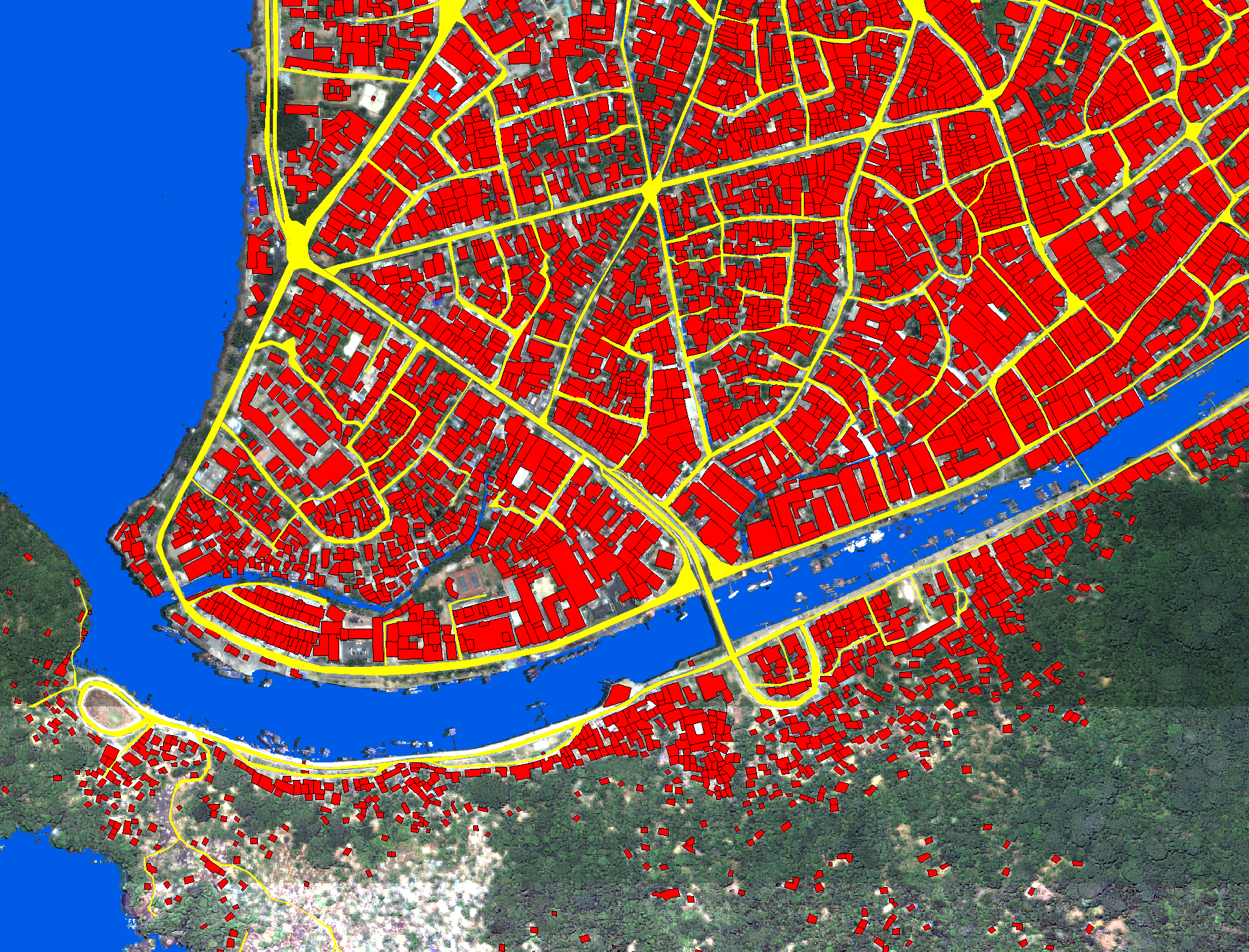
The small-scale and heterogeneous spatial variability of urban landscapes also reflects a spatial pattern of vulnerability and risk. The up-to-date and area-wide knowledge on urban structures is therefore basis for the preparation of an evacuation plan or the assessment of structural vulnerability. Figure 1 shows an Ikonos imagery displaying urban objects like buildings or streets in Padang from the year 2005 featuring a geometric resolution of 1 meter. A highly dense central district located directly on the highly tsunami prone coastline is displayed. (Figure 1 Ikonos). Using an object-oriented hierarchical classification approach the land-cover is extracted to know "what" is "where". As example the street network and the building-layers are presented as essential information basis for evacuation planning – assessing escape routes, assessing the carrying capacity of streets, or assessing the population distribution. A further structural classification of the built-up structures based on building density, height or size enables to correlate physical building types with stability of the structures.
Partners:
- United Nations University, Institute for Environment and Human Security (UNU-EHS)
- Franzius-Institut für Wasserbau & Küsteningenieurwesen, Fakultät für Bauingenieurwesen und Geodäsie; Leibniz Universität Hannover
- Institut für Land- und Seeverkehr, Technische Universität Berlin
- TraffGo HT GmbH; 47057 Duisburg
- RSS – Remote Sensing Solutions; D-81667 München
Contact: Hannes Taubenböck

