
msave - Multi-season remote sensing for monitoring vegetation
The introduction of the Habitats Directive (92/43/EEC) in 1992 led to the establishment of an EU wide network that provides a comprehensive protection of valuable and threatened species and habitats: NATURA 2000. About ten percent of is covered by 91 different habitat types in order to protect 133 species. In contrast to total reserve areas, many habitat types allow for sustainable human activities as long as habitat status does not degrade. Within the NATURA 2000 Network each EU member is obliged to collect information about habitats and report their status every six years.
The MSAVE project (http://www.msave.de) is funded by the DLR Space Administration, with means provided by the German Federal Ministry of Economics and Technology and it addresses the use of remote sensing methods for monitoring NATURA 2000 habitats and high nature value farmland from February 2011 until January 2014.
The project primarily addresses one major challenge in using remote sensing for vegetation monitoring: The investigated object – the vegetation itself - is highly variably both in space and time. The different habitat species are subject to a strong annual cycle with different phenological stages, e.g. leaf development, blossom, ripeness and senescence. This temporal variability further induces a spatial variability: One and the same habitat type in Northern Germany might currently be in a different condition than in Southern Germany.
Using a multi-sensor approach, the project seeks to evaluate the benefit of temporally high resolution remote sensing data and to develop new methods that take both natural non-stationarity and gradual intra-annual changes into account. To this end, several data sources will be used: Besides 10 years of hyper-temporal MODIS data, also high resolution optical RapidEye and WorldView data for the years 2011 and 2012 will be utilized. This (primary)data will be supplemented by TerraSAR-X and Radarsat as well as airborne hyperspectral data, in-situ-measurements and phenological dataprovided by the German Weather Service.
Project partners are the Vegetation Geography Group at the University of Bonn (project lead) and the Institute for Geoinformatics and Remote Sensing, University of Osnabrück.
The work packages of the department of Remote Sensing in Würzburg focus on the generation of time series on three scales:
- On the largest scale, MODIS data will be used to generate time series for Germany and neighboring countries.
- With spatial high resolution RapidEye data for two focus areas, time series for the years 2011 and 2012 will be generated.
- On the smallest scale, phenological observations for the dominant habitat species will be carried out in 2012 using a developed field protocol.
MODIS time series will be used to derive phenological metrics such as Start, End or Length of Season for different land use classes on the national scale using CORINE land cover for twelve years (see Figure 1). The spatio-temporal patterns will be analyzed using statistical methods and validated using phenological data provided by the German Weather Service to generate so called “phenological adjustment layers” that take different gradients (e.g. latitudinal, longitudinal, elevational) into account and serve as input data for the Maximum-Entrophy-Algorithm (work package of Bonn University).

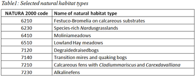
The main research topic of an integrated PhD-thesis is an Independent analysis of the impact of extreme weather events (e.g. droughts, frost) on different land cover classes.On the RapidEye scale, the phenological metrics will be validated using the species specific field protocols. It is assumed that RapidEye data with its high spatial resolution of 6.5m as well as high temporal resolution due to the sensor constellation can bridge the existing gap between land surface phenology (as seen from space) and phenology in a botanical sense. The main foci are several NATURA 2000 sites situated in the German Prealpine Foothills such as Molinia meadows (see Figure 2 and Table 1).

Contact: Carina Kübert
This project is funded by the Space Administration of the German Aerospace Center, with means provided by the German Federal Ministry of Economics and Technology, under project reference number 50EE1032.
Associated dissertation project: Fernerkundung für das Phänologiemonitoring: Optimierung und Analyse des Ergrünungsbeginns mittels MODIS-Zeitreihen für Deutschland

