DeltAdapt

- Subject: Costal agrosytems
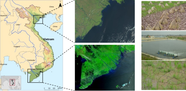
- Study site: Deltas of the Mekong and Red rivers (Vietnam)
- Funding: Federal Ministry of Education and Research
- Contact: Marco Ottinger
“Sustainable adaptation of coastal agro-ecosystems to increased salinity intrusion in Vietnam” (DeltAdapt)
DeltAdapt was a BMBF (German Federal Ministry of Education and Research) funded bilateral German-Vietnamese research project. The main focus was on drivers and consequences of socio-ecological changes of coastal agro-ecosystems in the Mekong River Delta and Red River Delta and their adaption options in the context of increasing salinization of water and soil resources.

In the Mekong and Red River deltas rice is the main crop and Vietnam’s rice export is ranked 3rd worldwide for milled rice. Climate change induced effects (sea level rise, changes in river discharge, salinity intrusion) and rapid socio-economic developments threaten the vulnerable agro-ecosystems. Salinity intrusion increasingly affects rice production while farmers try to adapt to changing environmental and economic conditions by shifting from paddy rice to rice-shrimp or even saline aquaculture. Management shifts in farming systems however are not feasible for all farmers and entail environmental risks.
The main focus of the multidisciplinary research project was to explore the current and historical land-use patterns, socio-ecological drivers of land-use changes, their feedback on climate and soil fertility, and evaluate the sustainability of the adaptation and adaptability of the coastal agro-ecosystems in both deltas to salinity intrusion and market challenges. Study areas located in the coastal regions of the Mekong Delta and Red River Delta served as examples of such highly vulnerable regions, where the production of rice, vegetables, and aquaculture products are crucial for the livelihood of local farmers. The Remote Sensing Unit of the University of Wuerzburg contributed to:
- Processing and analyses of high resolution satellite data (optical and radar)
- Mapping of land use in coastal study sites of the Mekong Delta and Red River Delta with a focus on paddy rice and aquaculture
- Development of processing workflows to analyze time series of earth observation data
- Analyses of land use changes and assessment of urban extents and coastline changes
The research consortium consisted of partners from the Institute of Crop Science and Resource Conservation (INRES) at the University of Bonn, the United Nations University


