Dr. Michael Thiel

Lehrstuhl für Fernerkundung
![]() +49 (0)931 31-84690
+49 (0)931 31-84690
![]() +49 (0)931 31-846900
+49 (0)931 31-846900
michael.thiel@uni-wuerzburg.de
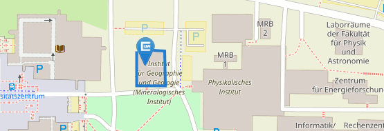
Institut für Geographie und Geologie
John-Skilton-Str. 4a
97074 Würzburg
Zimmer 01.B.02
nach Vereinbarung
Neben aller Emotionalität, die ich in meiner Arbeit (er)lebe, habe ich vorallem auch eines gelernt: Das Zulassen anderer Sichtweisen hilft mir, Aufgaben besser zu bewältigen. Ich biete gerne ein offenes Ohr und eine verständnisvolle neutrale Position im Gespräch.
seit 09/2012
Mensch-Umland-Beziehungen im Kontext des Klimawandels in Afrika mit Schwerpunkt auf Westafrika
2016 – 2017
Produktionsänderungen in ackerbaulich genutzten Flächen in Zentralasien
2007 - 2013
Promotion im Rahmen des BMWi Finanzierten Projektes „TerraSAR-X urban“. Titel der Dissertation: „Nutzung von Texturinformationen hochaufgelöster SAR-Daten zur Beschreibung von Siedlungsflächen“
2007 - 2013
Klassifikation einfach polarisierter SAR-Daten anhand Texturmaßen
2006 - 2011
Erfassung der Flächenversiegelung für die Bundesrepublik Deutschland aus Fernerkundungsdaten
seit 2023
Senior Scientist am Lehrstuhl für Fernerkundung, Projektleitung in den Projekten "MIGRAWARE", "ESPE", "AgriSens Demmin 4.0"
2012 - 2022
Projektleitung für den Lehrstuhl für Fernerkundung in den Projekten „WASCAL“, „TelePAtH“ und „WASCAL-DE-Coop"
2016 - 2017
Koordination des von der VolkswagenStiftung finanzierten Verbundprojektes „LaVaCCA“
03/2007 – 07/2011
Wissenschaftlicher Mitarbeiter am Lehrstuhl für Fernerkundung, Universität Würzburg
Mitarbeit in den Projekten „TerraSAR-X urban“ und „Versiegelung2006“
11/2006 - 02/2007
Mitarbeit an der Studie "Satellitengestützte Erfassung der Bodenversiegelung in Bayern" im Auftrag des Bayerischen Staatsministeriums für Umwelt, Gesundheit und Verbraucherschutz (StMUGV) und des Landesamtes für Umwelt
10/1998 - 08/2006
Studium der Angewandten Umweltwissenschaften an der Universität Trier
Hauptfächer: Fernerkundung, Klimatologie
Nebenfächer: Hydrologie, Bodenkunde
GGW
Geographische Gesellschaft Würzburg e.V.
VAD
Verein für Afrikawissenschaften in Deutschland
AWARD - One Planet Fellowship
Mitglied des wissenschaftlichen Beirats "AWARD - One Planet Fellowship"
Graduate School Climate Change and Land Use
Mitglied des internationalen Beitrats der Graduierten Schule "Climate Change and Land Use" an der Kwame Nkrumah University of Science and Technology in Kumasi, Ghana
Graduate School Science and Technology
PI der Graduate School Science and Technology an der Julius-Maximilians-Universität Würzburg
Forum Afrikazentrum
Mitglied des erweiterten Vorstands des Forum Afrikazentrum der Julius-Maximilians-Universität Würzburg
Review-Tätigkeiten
Remote Sensing of Environment, Remote Sensing, Journal of Photogrammetry, Remote Sensing and Geoinformation Science, Sensors, Ecological Indicators
-
. (2025): A Spatial Decision Support System for climate-adapted agriculture designed with and for stakeholders in West Africa. In: Climate Services, 39, 16.
-
. (2025): Dynamics of Changes in Spatial Patterns of Built-Up Areas in Two Metropolitan Areas of Grand Lomé and Greater Accra (West Africa). In: Urban Science, 9 (84), 20.
-
. (2025): Investigation of Data for Decision-Support in Forest-Related Natural Resources Management -With a Focus on Spatial Data on European and National Level
-
. (2025): One decade of institutional scientific output and impact in West Africa - The West African Science Service Centre on Climate Change and Adapted Land Use (WASCAL). In: Environmental Development, 56, 13.
-
. (2025): How do rural industrial sites impact migrant motives and the socio-economic conditions of local and migrant populations?. In: Scientific African, 27 (e02546), 18.
-
. (2025): Adaptation and Mitigation Strategies of the Populations of Abuja and Ouagadougou in West Africa to the Various Impacts of Extreme Climate Events in Urban Areas. In: Climate, 13 (7), 26.
-
. (2025): Earth observations reveal impacts of climate variability on maize cropping systems in sub-Saharan Africa. In: GIScience and Remote Sensing, 62 (1), 19.
-
. (2024): Enhancing Burned Area Monitoring with VIIRS dataset: A Case Study in Sub-Saharan Africa. In: Science of Remote Sensing, 10 (100165), 19.
-
. (2024): A multi-talented datacube: integrating, processing and presenting big geodata for the agricultural end user
-
. (2024): Integrating, Processing and Presenting Big Geodata with Earth Observation Datacubes in an Interdisciplinary Research Context
-
. (2024): Harmonized NDVI time-series from Landsat and Sentinel-2 reveal phenological patterns of diverse, small-scale cropping systems in East Africa. In: Remote Sensing Applications: Society and Environment, 35, 101230.
-
. (2024): Climate change related capacity development in West Africa – an example of a German-West African cooperation
-
. (2024): How Phenology Shapes Crop-Specific Sentinel-1 PolSAR Features and InSAR Coherence across Multiple Years and Orbits. In: Remote Sensing, 16 (2791), 26.
-
. (2023): Intensity Analysis for Urban Land Use/Land Cover Dynamics Characterization of Ouagadougou and Bobo-Dioulasso in Burkina Faso. In: Land, 12 (1063), 20.
-
. (2023): Scientific Evidence from Space — A Review of Spaceborne Remote Sensing Applications at the Science–Policy Interface. In: Remote Sensing, 2023 (15), 940.
-
. (2022): Deforestation in Continental Ecuador with a Focus on Protected Areas. In: Land, 11 (268), 26.
-
. (2022): Pathways to using remote sensing in crop cultivation and management - the German digital test field AgriSens DEMMIN 4.0
-
. (2022): Water use with cloud computing: prospective for food and water security in smallholder irrigation schemes
-
. (2022): Status-quo of selected nationally determined contributions using spaceborne remote sensing – the case of West Africa
-
. (2022): Afrikanische Schutzgebiete – Nutzungskonflikte und Gefährdungen. In: Geographische Rundschau, 3, 16-20.
-
. (2022): Estimation of Aboveground Biomass in Agroforestry Systems over Three Climatic Regions in West Africa Using Sentinel-1, Sentinel-2, ALOS, and GEDI Data. In: Sensors, 23 (349), 18.
-
. (2022): SAR phenology across major West-African land cover types
-
. (2022): Environmental Contamination of a Biodiversity Hotspot — Action Needed for Nature Conservation in the Niger Delta, Nigeria. In: Sustainability, 14 (14256), 21.
-
. (2022): Modelling the spatial distribution of the classification error of remote sensing data in cocoa agroforestry systems. In: Agroforestry Systems, 11.
-
. (2021): Relationship between soil sealing and local to regional climate in Germany. In: Meteorologische Zeitschrift, 10.
-
. (2021): Estimating maize lethal necrosis (MLN) severity in Kenya using multispectral high-resolution data. In: Applied Geomatics
-
. (2021): Detecting cocoa plantations in Côte d’Ivoire and Ghana and their implications on protected areas. In: Ecological Indicators, 129, 13.
-
. (2021): Monitoring von Freiflächeninanspruchnahme und -versiegelung für eine nachhaltige Raumentwicklung in Bayern. In: Raumforschung und Raumordnung - Spatial Research and Planning, 29.
-
. (2021): Coverage and Rainfall Response of Biological Soil Crusts Using Multi‐Temporal Sentinel‐2 Data in a Central European Temperate Dry Acid Grassland. In: Remote Sensing, 13 (3093), 26.
-
. (2021): Africa’s Protected Natural Assets: The Importance of Conservation Areas for Prosperous and Resilient Societies in Africa.
-
. (2021): Feldmessgeräte: 1. AgriSens FELDTAG „Einsatz von Fernerkundungstechnologien in der Landwirtschaft“
-
. (2020): Usage of MODIS NDVI to evaluate the effect of soil and water conservation measures on vegetation in Burkina Faso. In: Land Degradation and Development, 1-13.
-
. (2020): Investigation of Maize Lethal Necrosis (MLN) severity and cropping systems mapping in agro-ecological maize systems in Bomet, Kenya utilizing RapidEye and Landsat-8 Imagery. In: Geology, Ecology, and Landscapes, 16.
-
. (2019): Evaluation of gap-filling methods for Landsat 7 ETM+ SLC-Off image for LULC classification in a heterogeneous landscape of West Africa. In: International Journal of Remote Sensing, 21.
-
. (2019): Monitoring of the irrigated rice production dynamic in the Kazalinsk region, Kazakhstan, from 1984-2017. In: Central Asian Journal of Water Research, 5 (2), 20-43.
-
. (2018): Soil and Water Conservation in Burkina Faso, West Africa. In: Sustainability, 10 (9), 1-24.
-
. (2018): Remote sensing of soil salinity levels in irrigated cotton production systems in the Aral Sea Basin
-
. (2018): Monitoring biophysical parameters of irrigated rice production in the lowlands of the Aral Sea Basin from space
-
. (2018): Tapping the potential of Landsat archives for the monitoring of irrigated land use development in the lower Syr Darya catchment, Kazakhstan, 1984-2016.
-
. (2018): MODIS NDVI trends and fractional land cover change for improved assessments of vegetation degradation in Burkina Faso, West Africa. In: Journal of Arid Enviroments, 153, 66-75.
-
. (2017): Spatio-Temporal Patterns of Land Abandonment in the Lower Region of Amu Darya River. In: Tropentag 2017
-
. (2017): Maize Cropping Systems Mapping Using RapidEye Observations in Agro-Ecological Landscapes in Kenya. In: Sensor, 17 (11)
-
. (2017): Multiscale Remote Sensing to Map the Spatial Distribution and Extent of Cropland in the Sudanian Savanna of West Africa. In: Remote Sensing, 9 (8)
-
. (2017): High Resolution Mapping of Soil Properties Using Remote Sensing Variables in South-Western Burkina Faso: A Comparison of Machine Learning and Multiple Linear Regression Models. In: Plos one, 12 (1), 1-21.
-
. (2017): Peri-urban land use pattern and its relation to land use planning in Ghana, West Africa. In: Landscape and Urban Planning, 165, 280-94.
-
. (2016): Maize pest and diseas mapping using RapidEye-based vegetation indices and machine learning methods. In: Aarse 2016
-
. (2016): Identification of crop rotation systems in the Sudanian Savanna Zone in West Africa utilizing a multisensor approach. In: SPIE Remote Sensing
-
. (2016): Agricultural Land Use and Water Management in Central Asia - Insights into the projects CAWa and LaVaCCA. In: Drylands in Central Asia and Beyond: Insights and Innovations / Central Asian Seminar. Institutre for Asian and African Studies, Humboldt University of Berlin, Germany
-
. (2016): The use of RapidEye observations to map cropping systems in highly fragmented agro-ecological landscapes in Africa. In: 36th EARSeL Symposium
-
. (2016): Flood risk assessment and mapping in Abidjan district using multi-criteria analysis ({AHP}) model and geoinformation techniques, (cote d’ivoire). In: Geoenvironmental Disasters, 3 (1)
-
. (2016): Analysis of Settlement Expansion and Urban Growth Modelling Using Geoinformation for Assessing Potential Impacts of Urbanization on Climate in Abuja City, Nigeria. In: Remote Sensing, 8 (3), 220.
-
. (2015): Measuring rural settlement expansion in Uzbekistan using remote sensing to support spatial planning. In: Applied Geography, 62, 29-43.
-
. (2015): Multi-Temporal Landsat Images and Ancillary Data for Land Use/Cover Change (LULCC) Detection in the Southwest of Burkina Faso, West Africa. In: Remote Sensing, 7 (9), 12076.
-
. (2015): Evaluating the sequential masking classification approach for improving crop discrimination in the Sudanian Savanna of West Africa. In: Computers and Electronics in Agriculture, 118, 380-89.
-
. (2015): Regional differentiation in land use patterns and ist implication fo integrated land use planning in Ghana. In: IUFROLE WG Conference
-
. (2014): High resolution tree cover mapping in the West Sudanian Savanna based on multi-temporal Landsat data. In: 10th International Conference of the African Association of Remote Sensing of the Environment
-
. (2014): Comparison of Remote Sensing derived LULC in two rural test sites in the Sudanian Savanna Zone. In: Aarse 2014
-
. (2014): From High Resolution Remote Sensing Classification to Land-scape and Ecosystem Services Modeling in Northern Ghana. In: EARSeL SIG LULC
-
. (2014): Land Use/Cover Response to Rainfall Variability: A Comparing Analysis between NDVI and EVI in the Southwest of Burkina Faso. In: Climate, 3 (1), 63-77.
-
. (2014): Integration of Optical and Synthetic Aperture Radar Imagery for Improving Crop Mapping in Northwestern Benin, West Africa. In: Remote Sensing, 6 (7), 6472-99.
-
. (2013): Mapping tree cover change and the forcing drivers in West Africa. In: Global Geospatial Conference / AfricaGIS
-
. (2013): Improving agricultural land use mapping in West Africa using multi-temporal Landsat and RapidEye data. In: 5th RapidEye Science Archive (RESA) - From the Basics to the Service, Edited by Borg, E., Daedelow, H. and Johnson, R.pages, 57-72.
-
. (2013): Improving Crop Area Estimation in West Africa Using Multiresolution Satellite Data. In: AfricaGIS - Global Geospatial Conference 2013
-
. (unpublished PhD dissertation 2013): Nutzung von Texturinformationen hochaufgelöster SAR-Daten zur Beschreibung von Siedlungsflächen
-
. (2012): TanDEM-X mission-new perspectives for the inventory and monitoring of global settlement patterns. In: Journal of Applied Remote Sensing, 6 (1)
-
. (2011): Building detection from single polarized TerraSAR-X Data. In: Proceedings of the SPIE - The international Society for Optical Engineering
-
. (2011): Characterization of Land Cover Types in TerraSAR-S Images by Combined Analysis of Speckle Statistics and Intensity Information. In: IEEE Transactions on Geoscience and Remote Sensing, 49 (6), 1911-25.
-
. (2010): Land Cover Classification based on single-polarized VHR SAR images using texture information via speckle analysis. In: Proceedings of the 2010 IEEE International Geoscience and Remote Sensing Symposiumpages, 1875-78.
-
. (2010): Estimation of building density using TerraSAR-X-Data. In: Proceedings of the 2010 IEEE International Geoscience and Remote Sensing Symposiumpages, 1936-39.
-
. (2010): Urban Remote Sensing - How Can Earth Observation Support the Sustainable Development of Urban Environments?. In: 15th International Conference on Urban Planning, Regional Development and Information Society (REAL CORP)pages, 837-47.
-
. (2010): Delineation of Urban Footprints From TerraSAR-X Data by Analyzing Speckle Characteristics and Intensity Information. In: IEEE Transactions on Geoscience and Remote Sensing, 48 (2), 905-16.
-
. (2010): Supporting the Sustainable Development of Cities by Means of Earth Observation Techniques. In: Isocarp 2010
-
. (2009): Large-area assessment of impervious surface based on integrated analysis of single-date Landsat-7 images and geospatial vector data. In: Remote Sensing of Environment, 113 (8), 1678-90.
-
. (2009): Assessment of urban extend and impervious of Cape Town using TerraSAR-X and Landsat images. In: Proceedings of the 2009 IEEE International Geoscience and Remote Sensing Symposium
-
. (2009): Monitoring and assessment of urban environments using space-borne earth observation data - selected applications. In: Urban and Regional Data Managementpages, 385-98.
-
. (2008): Object-oriented detection of urban areas from TerraSAR-X data. In: Proceedings of the International Archives of the Photogrammetry, Remote Sensing and Spatial Information Sciences (ISPRS), Part B8, Commission VIII
-
. (2008): Classification of urban environments with TerraSAR-X and ALOS-PALSAR data. In: Spie 2008
-
. (2008): Improvement of Image Segmentation Accuracy based on Multi-Scale Optimization Procedure. In: IEEE Geoscience and Remote Sensing Letters, 5 (3), 463-67.
-
. (2008): Object oriented detection of settlement areas from Terra SAR-X data. In: Proceedings of the EARSeL Joint Workshop
-
. (2008): Comparison of ALOS-PALSAR and TerraSAR-X data in terms of detecting settlements – first results. In: Proceedings of the ALOS PI Symposium 2008
-
. (2008): Analysis of SAR speckle statistics in support of image filtering and interpretation. In: Proceedings of the 2008 IEEE International Geoscience and Remote Sensing Symposium
-
. (2008): Model-based estimation of impervious surface by application of support vector machines. In: Proceedings of the International Archives of the Photogrammetry, Remote Sensing and Spatial Information Sciences (ISPRS), Part B8, Commission VIII
-
. (2008): Urban structure analysis of mega city Mexico City using multisensoral remote sensing data. In: Spie Europe Remote Sensing 2008, 1-12.
-
. (2008): Identification of built-up areas using SAR data – A comparison of TerraSAR-X and ALOS PALSAR imagery. In: Proceedings of the SPIE Europe: Remote Sensing Conference - Image and Signal Processing for Remote Sensing XIV
-
. (2008): Urban structure analysis of mega city Mexico City using multi-sensoral remote sensing data. In: Proceedings of the SPIE Europe: Remote Sensing Conference - Remote Sensing for Environmental Monitoring, GIS Applications, and Geology VIII
-
. (2007): Monitoring of Urban Environments with TerraSAR-X Data. In: Proceedings of the 2007 IEEE International Geoscience and Remote Sensing Symposium
-
. (2007): Satellitengestützte Erfassung der Bodenversiegelung in Bayern. In: Broschüre des Bayerischen Landesamts für Umwelt
-
. (2007): Versiegelung in Bayern - Ergebnisse einer flächendeckenden satellitenbasierten Untersuchung


