
Completed projects

BIOTA West
The project is part of the BMBF priority program BIOLOG, which also includes BIOTA-Süd. In West Africa, the distribution patterns of certain taxa are evaluated on the basis of remote sensing data, in situ collections and models. Monitoring and analysis of fragmentation of large ecosystems, the analysis of economies of scale on the informational content of remote data and the impact of the temporal and spatial fire cycle on biodiversity will be examined.

BIOTA Süd
The aim of the project is to investigate the interactions between biotic and abiotic components in the structure of the current biodiversity in southern Africa. The chair supports this by preparing, providing and analyzing a variety of remote sensing data. Central research focuses on the monitoring and analysis of seasonal and multi-annual vegetation dynamics as well as the development of remote-sensing-based methods for the classification of the vegetation structure and for recording and assessing current land-change processes.
CATENA
For a process chain for the processing of satellite data implemented by the German Remote Sensing Data Center of the German Aerospace Center (DLR-DFD), a module is being developed which enables automatic radiometric adaptation of different data from different optical sensor systems. This preprocessing step allows for further modeling or mapping in study rooms beyond the scope of individual datasets.
CatchMekong
- Subject: Sustainable and transboundary water management
- Study site: Mekong river basin (Vietnam)
- Funding: Federal Ministry for Education and Research
- Contact: Chunzhu Wei

CAWa - Central Asia Waters
- Subject: Agriculture and water management
- Study site: Central Asian (Kyrgyzstan, Uzbekistan, Tajikistan, Turkmenistan and Kazakhstan)
- Funding: Framework of the Berlin Process of the Federal Foreign Office
- Contact: Christopher Conrad

CONABIO
The Mexican Commission CONABIO (Comisión Nacional para el Conocimiento y Uso de la Biodiversidad) is primarily concerned with collecting information on Central American flora and fauna and developing or adapting the National Biodiversity Information System (SNIB - Systema Nacional de Información sobre Biodiversidad de México ). The aim is to promote, coordinate, support and carry out activities for the conservation of biodiversity and its sustainable use for the benefit of society. CONABIO has been designed as an organization for applied research that supports basic biodiversity research and is a publicly available source of information and knowledge.
DeltAdapt - Sustainable adaptation of coastal agro-ecosystems to increased salinity intrusion in Vietnam
- Subject: Costal agrosytems
- Study site: Deltas of the Mekong and Red rivers (Vietnam)
- Funding: Federal Ministry of Education and Research
- Contact: Marco Ottinger
DELTAS - Nachhaltige Deltas 2015
- Subject: Socio-ecological systems in Deltas
- Study site: Amazonas (Brazil)
- financing: Belmont Forum
- Contact: Benjamin Mack
EIFER
A classification method for arable land from multiscale satellite data is being developed for the European Institute for Energy Research (EIFER). The objectives are to provide a transferable and cost-effective method as well as the detection of grain for the capture of bioenergy potential in southwestern Germany.
EO-MOVE
- Subject: Animal movement and animal behavior
- Study site: Russia and Continental Europe
- Funding: Federal Ministry for Research and Energy
- Contact: Benjamin Leutner
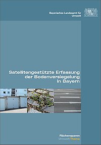
Fernerkundungsbasierte Erhebung der Versiegelung in Bayern
As part of the study "Remote sensing based survey of sealing in Bavaria" commissioned by the Bavarian State Office for the Environment, a nationwide standardized and objective survey of the sealing with a high spatial level of detail for the year 2015 is carried out. Based on methods developed in the previous study, the degree of "sealing of the settlement and traffic area" and the "sealed settlement and traffic area per inhabitant" for the Free State of Bavaria and its administrative and spatial structural sub-areas (municipalities, districts, administrative districts, planning regions , Area categories of the state development program Bavaria). The basis for these analyzes are data from the Landsat 8 and the official Topographic Cartographic Information System (ATKIS).
GLAM.de - Global Agricultural Monitoring
- Subject: Agricultural monitoring
- Study site: Northern Germany
- Funding: Federal Ministry of Economics and Energy
- Contact: Nima Ahmadian

GLOWA-Volta
The GLOWA Volta project is an interdisciplinary project that supports sustainable water resource management in the Volta Basin. The main objective is to develop a Decision Support System (DSS) that gives ministries in Ghana, Burkina Faso and other neighboring states the opportunity to optimize water use.

GITEWS
The project GITEWS is concerned with the construction of a tsunami early warning system in the Indian Ocean. For this purpose, various sensors are installed in the region in order to obtain information about the probability of a tsunami and its magnitude as soon as possible after tectonic events. Another focus of the project is the promotion of awareness of tsunamis in the region and thus the long-term development of a strategy to avoid the loss of life.

GlobWetland II
GlobWetland II is a component of the Data User Element (DUE) of the European Space Agency (ESA) and aims to contribute to the establishment of a Global Wetlands Observing System (G-WOS) for the 2009-2015 Ramsar Strategic Plan Global Wetlands Observing System A pilot project is being undertaken to develop remote sensing-based geo-information products for habitat mapping according to RAMSAR guidelines and indicators on the status and trends of important wetlands in the Mediterranean using 200 RAMSAR wetlands, which will be provided in the form of a web-based information system.
InoCottonGrow - Innovation to Reduce the Water Footprint of the Global Cotton Textile Industry
- Subject: Agriculture and water management
- Study site: Germany, Turkey, Pakistan
- Funding: Federal Ministry for Research and Energy
- Contact: Muhammad Usman

Khorezm
The BMBF-funded German-Uzbek project "Ecological and economic restructuring of land and water use in Khorezm, Uzbekistan" is an interdisciplinary project in the field of development research. The research is concerned with the difficult ecological and economic situation in the Soviet-era growing areas in the alluvial areas of Amu Darja.

LAST-MILE
In this research project, a numerical load-mile tsunami early warning and evacuation information system will be developed using detailed earth observation data and techniques, as well as transient, hydronumeric simulation of small-scale flood dynamics including modeling of the escape behavior in the urban coastal hinterland of Padang City, West Sumatra, Indonesia. Due to its immediate coastal location, the third largest city in Sumatra, with a population of about 1 million, is the highest risk zone in a region threatened by earthquakes and potentially tsunamis. This project therefore focuses on the modeling of flooding dynamics and climate change physical-technical vulnerability including the socio-economic vulnerability of the population to mitigate the damage caused by such natural disasters.
LaVaCCA
The aim of the research project "Assessing Country Value Changes and Developing a Discussion Support Tool for Improved Land Use Planning in the Irrigated Lowlands of Central Asia" (Lavacca) to identify areas of decreasing of agricultural production in the irrigated areas of Central Asia is as well as by socio- economic and environmental indicators to identify those factors that cause the observed changes in agricultural production and land degradation. Based on this, economic analyzes of land use alternatives under the given ecological conditions are planned. Methodological focus is on the intensive use of remote sensing, in conjunction with Geographical Information Systems (GIS), indicator systems, land use modeling and on the economic optimization of recent land use. The information generated in this way can be used as a "discussion support" to support politicians and decision-makers in their efforts to secure food security and combat environmental degradation in the irrigated regions of Central Asia.
The project is funded by the Volkswagen Foundation until 12/2017.
MedWater (GROW) - Sustainable use of politically and economically relevant water resources in hydraulically, climatically and ecologically highly dynamic hard-rock aquifers in the Mediterranean region
- Subject: Agriculture and water management
- Study site: Mediterranean Region
- Funding: Federal Ministry for Education and Research
- Contact: Sarah Schönbrodt-Stitt
msave
With the introduction of the Flora-Fauna-Habitat-Directive (FFH) in 1992, an instrument was adopted which ensures the comprehensive protection of certain species in a Europe-wide network (NATURA2000). For Germany, 91 habitat types (LRT) with 133 different species were identified. The share of FFH areas in Germany amounts with 9.7% to about one tenth of the country's surface. In contrast to the total reserves, these areas permit human intervention, but the condition of the habitats must not deteriorate. A reporting obligation to the EU should check this status every 6 years.The project msave, which was funded by the DLR agency from February 2011 to January 2014, will highlight the possible uses of remote sensing for monitoring and describing the status of LRT and High Nature Value Farmland (HNV).
Opt4Environment
The characterization and monitoring of biodiversity is of high value to natural and managed ecosystems. The Opt4Environment project will develop and analyze remote sensing strategies and biodiversity description methods for two different applications. The first part will examine animal movements and their environmental interactions. The second part will focus on the condition and development of the apartments.
PhenoS
- Subject: Landwirtschaft Phänologie
- Study site: Süddeutschland
- Financing: Bundesministeriums für Wirtschaft und Energie
- Contact: Thorsten Dahms

Refina
The interdisciplinary research project Refina aims at the development of a remote sensing based area barometer for the qualitative and quantitative assessment of current and historical land use in the Federal Republic of Germany. In addition to the provision of data and indicators for the three scale levels federal, state and regional, the goal is the definition of a method set for characterizing the indicators "land use" and "land sealing". In this context, effective determinants should be derived and approaches developed to assess the sustainability of land use.
SAR-based Monitoring of agricultural Areas (PhenoSAR-Demmin)
- Subject: Agriculture and phonological monitoring
- Study site: Demmin
- Funding: German Aerospace Center (DLR)
- Contact: Johannes Löw

SoeRS
The object of this research project is to develop new analysis possibilities through the combined evaluation of remote sensing data and socio-economic data. The interdisciplinary project SoeRS (Synergies in Socioeconomic and Remote Sensing Data) is based on a cooperation with the Department of Socio-Economic Panel Study (SOEP) of the German Institute for Economic Research (DIW). Since 1984, this organization has carried out the annual survey of "life in Germany" among private households throughout Germany, providing this data for social and economic research. The dataset provides information on many objective living conditions and personality traits and on dynamic dependencies between the areas and their changes.
Techs4TimeS
- Subject: Biophysikalische Parameter, Zeitreihen, Daten Fusion
- Study site: DEMMIN
- Financing: Bundesministeriums für Wirtschaft und Energie
- Contact: Thorsten Dahms

TerraSAR-X urban
Within the project TerraSAR-X, funded by the Federal Ministry of Economics and Technology (BMWi) until 2011, techniques for advanced preprocessing and object-oriented as well as pixel-based analysis of images of the high-resolution German radar satellite TerraSAR-X were developed. The aim was to provide methods for recording spatial changes in urban areas, from which in turn further planning-relevant information can be derived. The approaches developed as part of the research were implemented in close collaboration with project partners from industry and science.
Trend analysis of remote temporal time series for the phenological monitoring of bark beetle infested areas (MIRS)
Bark beetle mass multiplication is one of the largest natural disturbance processes in forests besides storm throws in Central Europe and plays an important role in natural forest dynamics. Large-scale disturbances caused by bark beetle epidemics can lead to a far-reaching change in vegetation phenology. A timely, areal, and in particular repeated, uptake of infestation-modified phenology in the field is often unrealistic. Spatially explicit, multitemporal remote sensing data are therefore an interesting alternative or supplement to data measured in the field. The use of medium-resolution earth observation data (e.g., Landsat, SPOT, and Sentinel) for phenological investigation in connection with bark beetle infestation appears promising and has not been adequately studied in Central Europe.
Imperviousness study 2006
On behalf of the Federal Institute for Research on Building, Urban Affairs and Spatial Development (BBSR), the Department of Remote Sensing of the Geographical Institute of the University of Würzburg therefore conducts a nationwide standardized and objective survey of sealing with a high degree of spatial detail. The basis for this is a technique for largely automated mapping of surface sealing based on satellite images and data from the Official Topographic-Cartographic Information System (ATKIS), which was developed in the course of a study for the State Office for the Environment, Bavaria (LfU) and expanded within the scope of the Refina project has been. For the year 2000, such an investigation has already been carried out in the context of the Refina project.

Inperviousness in Bavaria
In the framework of the study "Satellite-based detection of soil sealing in Bavaria" commissioned by the Bavarian State Office for the Environment, a nationwide standardized and objective survey of the sealing with a high degree of spatial detail was carried out for the first time. The basis was the development of a technique for the largely automated, Bavaria-wide mapping of surface sealing based on satellite images and data from the Official Topographic-Cartographic Information System (ATKIS). Based on this data basis, both the 'degree of sealing of the settlement area and the traffic area' as well as the 'sealed settlement and traffic area per inhabitant' for the Free State of Bavaria and its administrative and spatial subregions (municipalities, counties, administrative districts, planning regions, Area categories of the Bavarian State Development Program).
WASCAL
- Subject: Climate change and land use
- Study site: Africa
- Funding: Federal Ministry of Education and Research
- Contact: Michael Thiel
WUEKIS – Showcasing Remote Sensing Data and Products for Bavaria
- Subject: Land use, Bavaria
- Study site: Bavaria
- Funding:
- Contact: Thorsten Dahms

